Many people wonder if California will one day fall off of North America and end up sinking into the Pacific Ocean. Luckily, this will never happen.
California is bisected by the widely known, San Andreas Fault. The San Andreas Fault is a Strike-Slip Fault that lies on the boundary of the Pacific and North American Plates. One thing that many people don't know is that the two plates are grinding past each other and not pulling apart or smashing underneath each other. As a result, Los Angeles (which lies on the Pacific Plate), is slowly moving closer to San Francisco (which lies on the North American Plate), at a rate of 1.3-1.5 inches annually.
It would be impossible for California to fall into the Pacific Ocean, because The Pacific Ocean is on the same plate that the western half of California lies on!
Rainfall Totals from Hurricane Kathleen- 1976
Courtesy of NASA
Did you know that the Last Tropical Cyclone that impacted Los Angeles County was the 1939 Long Beach Tropical Storm. It made landfall on September 25, 1939, in San Pedro, California and caught many people unprepared because it wasn't anticipated by the Weather Bureau. Winds reached 75 mph and the storm caused flooding, killing many people, most of which were out at sea.
Other Tropical Cyclones directly affected Southern California more recently, one of which is Hurricane Kathleen that entered the United States near the Salton Sea in 1976, as a Tropical Storm. It caused gale force winds and over 14 inches of rainfall were recorded in San Gorgonio, CA. Catastrophic flooding occurred in Ocotillo and in the Palm Desert, and over $160 million in damages occurred.
An even more recent Tropical Storm, Tropical Storm Nora made landfall near the California-Arizona Border in 1997, and caused over 11 inches of rainfall in Yuma, Arizona. Approximately, $150-200 million, in damages occurred.
Tropical Storms and Hurricanes rarely hit California due to the cold ocean temperatures and prevailing winds. But it is not impossible.
A Gray Hairstreak Butterfly on Black Sage (Image Property of SoCal Earth Science Blog)
Did you know that much of the highly populated regions of Southern California were not deserts? Deserts exist on the Rain Shadow side of mountains, and receive very little winter rainfall.
Most of the highly populated regions of Southern California were in Coastal Sage Scrub. The habitat lies within the Mediterranean Climate and receives more rainfall than the deserts. Much of it has been lost to development, and many endangered and threatened species live within it (Examples: The California Gnatcatcher and The El Segundo Blue Butterfly).
Plant species that live within Coastal Sage Scrub include California Sagebrush (Artemisia californica), California Buckwheat (Eriogonum fasciculatum), Coast Sunflower (Encelia californica), Black Sage (Salvia mellifera), White Sage (Salvia apiana), Lemonade Berry (Rhus integrifolia), Toyon (Heteromeles arbutifolia), and many more.
Last night at 3:18 in the morning PST, a mild 3.7 magnitude earthquake struck in Westchester, in Los Angeles County. It was felt throughout the Los Angeles Area and was also felt as far away as San Diego (supposedly). The greatest intensity reading of this earthquake was registered at IV near the epicenter.
The original ecology of the Ballona Creek Watershed
The Ballona Wetlands is a 600 acre ecological reserve, located near Playa Del Rey in Los Angeles County. It is the last wetlands in Los Angeles county and once filled the area from Venice to the Westchester Bluffs, but was lost through a century of development.
In the 1920's people in search of oil ravaged the land and polluted it to a point of disaster. In the 1930's the Ballona Creek was channeled and realigned, separating the wetlands from the creek, causing the loss of tidal influence on the habitat.
Ballona Wetland Acquisitions Courtesy of the Sierra Club
You would think that the situation could not get any worse, but it did. In the 1960's the construction of Marina Del Rey destroyed over 900 acres of the wetlands, and a majority of the remaining wetlands were filled with dredged soil that was left over from the creation of the harbor.
When Howard Hughes died in 1976 a majority of his land, which included a majority of the wetlands was quickly targeted by developers. The Summa Corporation Playa del Vista Plan, which proposed to develop 1,115 acres of the wetlands and open space, planed to only leave a minuscule 72 acres of wetlands to be restored.
The Ballona Freshwater Marsh with the Playa Vista Development in the Background (Image Property of SoCal Earth Science Blog)
When the Summa Corporation sold the development to Maguire Thomas Partners in 1990, the company negotiated with wetland supporters (Friends of the Ballona Wetlands). As a result of negotiations, a significant portion of the wetlands was saved. By 2003, around 600 acres of the wetlands were preserved. To this date, the Friends of the Ballona Wetlands are restoring the degraded wetlands, and The Santa Monica Bay Restoration Commission has proposed a plan that will reconnect the Ballona Creek with the wetlands through the removal of the concrete levees encasing the creek.
In 2009 the US Geological Survey created earthquake hazard maps to identify earthquake hazards throughout the entire United States. Shown here is the probability of high ground movement in Southern California. As you can see, the possibility of high ground shaking in Southern California is quite high, especially along the San Andreas Fault.
Fortunately, the building codes in California arestrict, and there is a very low chance that your home, school (After the Long Beach Earthquake strict building codes for schools were created), or office, will collapse in the event of a major earthquake. In Japan during the magnitude 9.0 Tohoku Earthquake, few buildings collapsed, and most damage was sustained through the tsunami. Luckily in Southern California, there are no Subduction Zones off the coast (like in the Pacific Northwest), so a tsunami of that magnitude is very unlikely.
Create an earthquake kit that has enough food and water for your family for at least three days, along with a fire extinguisher, a battery powered radio, a flashlight with batteries, and a first aid kit. Make sure you have your important medications(if needed), and pet food (if you have a pet). Make an emergency plan with your family to figure out how you will meet up after a large earthquake. Protect your belongings. Fasten shelves to walls, and secure heavy objects such as TVs, computers, and water heaters. There is a great document that highlights earthquake preparedness in the home titled Putting Down Roots in Earthquake Country.
Although the chance of building collapse is small, it is still important to retrofit unreinforced masonry and old concrete buildings, and to bolt your house down to its foundation. Such projects are worth it in the long run.
If you are indoors during an earthquake, immediately Drop, Cover, and Hold on, if you are near a sturdy table. If you are near a sturdy, supported doorway (not a weak unsupported doorway) stand in it. Otherwise, crouch near an inside wall, away from windows, or objects that can fall on you. Cover your head and neck, and do not move until the shaking stops.
Most earthquake related injuries and deaths are related to falling debris, so it is important not to run outside of a building where dangerous building facades can collapse on you.
If you are outdoors, stay there. Try to move into the open, away from telephone poles, trees, or buildings. Crouch to the ground, and wait for the shaking to subside.
If you are in a car and you feel an earthquake, turn on your hazard lights, and carefullypull over to the side of the road. Try to stay away from bridges, overpasses, and large signs that can fall on you.
After the earthquake, if you smell gas, turn off the gas supply to your house. If you do not smell any gas, you do not need to turn off the gas supply to your house.
The Great California Shakeout
In preparation for the next large earthquake, visit: http://www.shakeout.org/california/ to participate in the next "Great California Shakeout".
This post has been replaced by A Background on Earthquake Early Warnings, found in the tabs at the top of the page.
Since the time earthquake monitoring began, scientists have wondered
if earthquake prediction is possible. Some scientists attempted to link
earthquakes with previous seismic activity, radon emissions, changes in the magnetic field and animal behavior. None of these earthquake
“prediction” attempts were successful.
The QuakeGuard Warning System
In the
1990’s, a commercial group began producing QuakeGuard Seismic Warning Systems
that use a seismometer placed under a location that detects the harmless, fast
moving primary waves of an earthquake, that arrive before more damaging S and Surface waves. The system then alerts the user by setting off an alarm, and
sometimes even shutting off the gas supply before the arrival of the damaging
Surface waves. QuakeGuard was the first operational version of an earthquake
early warning system that was able to alert users tens of seconds ahead of a
large earthquake, with no false positives.
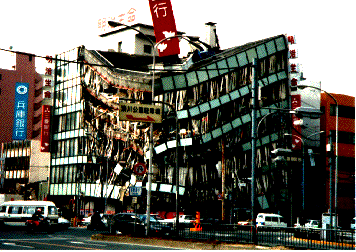
Kobe Earthquake Damage
In the 1990's seismologists in Mexico City created a simple earthquake early warning system that involved seismometers placed on a fault off the coast. When shaking was detected by the seismometers, sirens in the city would sound, giving precious seconds to evacuate un-reinforced buildings.
On
January 17, 1995 at 5:46am (Japan Standard Time), a 6.8 magnitude earthquake
struck Kobe, the capital of Hyogo Prefecture in Japan. The quake killed over
140,000 people and caused about 100 billion dollars in damages.
Following the quake Japan started work on a nation-wide
earthquake early warning system to help save lives in the event of another
major earthquake. This system implemented 4,235 seismometers throughout the
country to estimate the intensity of an earthquake and to deliver an early
warning to all of its users in the affected areas. The system was first implemented
to slow down bullet trains and finally, on October 1, 2007, was put into place
nationally. It was ready to alert millions through text messages, TV
alerts, radio broadcasts, sirens, and government approved Earthquake Early
Warning compatible products.
The system proved its usefulness when on March 11, 2011 at
2:46pm (Japan Standard Time); a 9.0 megathrust earthquake struck its coast.
Eight seconds after the earthquake began, seismometers offshore Miyagi
Prefecture recognized the fastest moving (P) waves of earthquake and
immediately sent earthquake early warnings to the Tohoku Region of Japan. Earthquake early warning messages interrupted radio
and TV broadcasts automatically. Two sets of computer generated chimes rang,
followed by a prerecorded announcement of a man saying the following, “緊急地震速報です。強い揺れに警戒して下さい。 (Kinkyu
jishin sokuho desu. Tsuyoi yure ni kekai shite kudasai.)” Translated, the passage reads, “This
is an earthquake early warning. Please prepare for powerful tremors.” Although
the city of Tokyo received up to a minute of warning time, in Sendai (closest
to the epicenter) the warning was only fifteen seconds. Although fifteen seconds may not seem like much time, five
seconds is a sufficient amount of time to duck and cover under a sturdy desk. Few
people died in the earthquake’s shaking, proving the system’s effectiveness. Unfortunately
the tsunami that followed killed 15,845 people with 3,380 people still missing,
creating a need for larger seawalls and more efficient tsunami warnings.
Seismologists from
Caltech, USGS Pasadena, USGS Menlo Park, and UC Berkeley, have teamed together
with the California Integrated Seismic Network to create and perfect an
earthquake early warning system for California, and later for the entire United
States Pacific Coast. In 2011 a rough earthquake early warning system was
created, and is currently being tested by selected seismologists, the Bay Area
Rapid Transit System, and other companies and government organizations
throughout California.
Like most functioning systems, there are some issues:
1. Point Source Approximation. The system is only able to perceive that an earthquake radiates from one point, not a rupture along a fault line. 2. Seismometer spacing. There are few seismometers along the Central California and Northern California Coast to
detect earthquakes quickly. Seismometer spacing must be reduced to 12 miles apart from each other.
3. Funding. A system along the West Coast
would cost approximately one-hundred and fifty-million dollars over five years to perfect, and several million dollars more per year to fund.
On November 29, 2012 the Gordon and Betty Moore
Foundation provided a 6 million dollar grant to help fund the Earthquake Early
Warning System. Although a system would cost over
$150,000,000, it would, in the long run, lessen costs of damages by earthquakes, by stopping production lines, and other sensitive industries, and will reduce personal injury caused by falling debris.
Update: 1/29/13 In January 2013 a bill was created to possibly fund an $80 million dollar earthquake early warning system for California.
Earthquake Early
Warnings have saved lives in many earthquake prone countries over the past few
years. Unfortunately it often takes the loss of thousands of lives to fund such
a system. Hopefully, a system will be publicly implemented on the West Coast of
the United States without another devastating earthquake to catapult its creation.
 Many people wonder if California will one day fall off of North America and end up sinking into the Pacific Ocean. Luckily, this will never happen.
 California is bisected by the widely known, San Andreas Fault. The San Andreas Fault is a Strike-Slip Fault that lies on the boundary of the Pacific and North American Plates. One thing that many people don't know is that the two plates are grinding past each other and not pulling apart or smashing underneath each other. As a result, Los Angeles (which lies on the Pacific Plate), is slowly moving closer to San Francisco (which lies on the North American Plate), at a rate of 1.3-1.5 inches annually.


